|
|||||
| darkroom | conservation | panoramics | experimental | education | location |
Foreword When I planned walking The Hebridean Way last year, I searched the internet for information regarding the pathway, the islands, interesting places etc. What I never found was a route map to follow and I relied on OS maps to plot my journey. When I recently searched the internet regarding the Outer Hebrides and The Hebridean Way, I discovered a link provided by Visit Outer Hebrides defining the route and the path to follow, avoiding the roads where possible, and exploring the ancient pathway from post to post. For anyone venturing up the Islands by foot, here is a link to the journey I should have took. Rob 2017
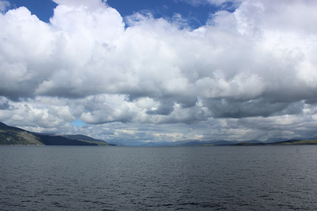
I set sail from Oban with high anticipation of the journey ahead of me, through the Sound of Mull, I cross the open sea to Barra, an island of the Outer Hebrides, intent to explore the western Machair; the grassy, sandy, exposed coastal dunes of the southern isles of Barra, South Uist, Benbecula, North Uist and Berneray and trek north along the soon to be launched1 'Hebridean Way';
“The walking route is comprised of purpose built sections and also makes use of existing footpaths, peat tracks, quiet roads and traditional rights of way. Steeped in History, the Hebridean Way stretches 185 miles along the length of the Outer Hebrides from Vatersay in the south to the Butt of Lewis in the north... The route passes through 10 Islands linked by a combination of causeways and ferries, over rugged hills and along dazzling Atlantic coastline... The stunning landscapes, the geology, wildlife, heritage and scenery of the Outer Hebrides are truly awe-inspiring. ”2.
I knew little of the Machair bar its famed yellow bumble bee that inhabit the flowery sandy meadows along the route, that the beaches were phenomenal; the result of several Millennia of Atlantic waves battering an onslaught of erosion, and early neolithic settlers had left their mark on a fertile land that now sits exposed to the elements; the Atlantic winds from the north and the west more suited to the extensive wild bird life than perhaps this Journeyman, but I was keen to experience this unique eco-system, where once invading Vikings had farmed, and now a strong Gaelic community continue the practice. I had been aware of the generous beaches along the west coast since first visiting the northern Isle of Lewis and the Stones at Callanais twenty years ago and seeing sandy coves to the west and south marked on the OS map, and thought that perhaps they were the most remotest this country had to offer, and despite the mixed weather forecast for the weeks ahead, I was excited at the thought of the journey, aware that any shelter would be hard to find if the rains were to turn to the worst and my journey may be dampened if forced to retreat. However, I was prepared for all expectations, ready to learn along the way, laden with the easily bearable necessary equipment for survival, and, I guess, fit for anything.
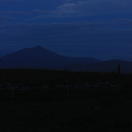
Arrival at Barra by ferry is greeted by the medieval Kiessimul Castle, the castle in the sea, which was said to be the influence of Hergé's Adventures of Tintin to The Black Island. The small island has a central moorland hill peaking at 383m, that stands protectively behind the harbour town of CastleBay. It is late afternoon and unaware of how time will allow for my pace, I immediately venture left out of the town following the road toward the west coast with views of the sunset and the sea and my first night of camping.
My plan to follow the route north along the western pathway omitted the first island of the group, Vatersey which was situated south westerly of Barra and linked by a new causeway3, for unfortunately on a walking journey it is impossible to see everything as time does not allow.
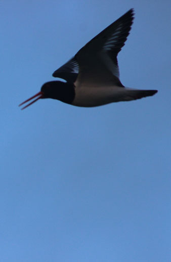
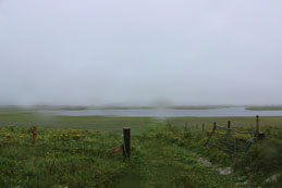
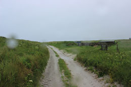
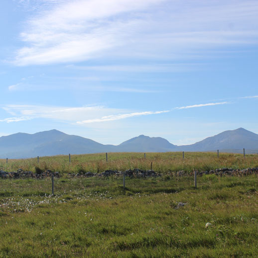
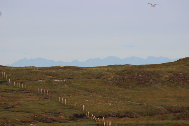
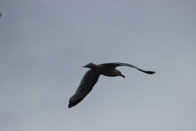
The sun is out, the air is fresh, the evening is calm but the breeze is apparent. It also becomes immediately apparent that the walking will remain on the road, at least for a while and the immediate discomfort of the hardened tarmac, coupled with the fresh weight of my backpack, water and supplies, bear heavy on my soft soled city feet. The map shows few open trails and the roads are lined with barbed wire fencing, presumably to keep grazing sheep away from traffic, maybe to confirm land ownership, but certainly keeping me and future hikers within the confines of the single lane route around the island. After a few miles the road meets the sea and my pace is fast, for the path is smooth, as I follow the road and the coast further taking in the open view ahead and out to sea. I cook and eat a hot dinner nestled in the rocks, away from the breeze, at the first public viewpoint where I can access the sand and the sea and a little later and a little further I hop a fence at the first local access point I see; a small stile with the barbed wire wrapped in rubber tubing, and follow the faint footpath onto the large expanse of open dunes where the cows were grazing on a grassy promontory away from the road, and I set up my bivouac in a shallow hollow in the grassy dunes above the beach and sit back to enjoy the sunset and watch an array of oystercatchers, gulls, terns and plovers feeding amongst the kelp and the seaweed washed up between the rocks and white sands that lay before me.
My first night is a peaceful and dream-full one, the skies stay clear and the sun shines as I awake and pack up and explore the sandy beach that had sat beside me as I slept, ever aware of the changing tide, fresh with the morning life of the new day. I venture back to the road and now continue my route inland to take the road to the north easterly point of the island where a ferry will carry me the short distance to the next island of Eriskay. I stop twice on route. Once by a picturesque roadside loch, where I abandon by backpack for an hour or two and take a path up, into the moorland, covered with swaying white bog cotton, up to a remote, and still, loch set in the hillside. The second break was at the junction of the loop road, where I was to to turn left, and I sat on the harbour wall, snacking at my lunch, near the village of NorthBay, and enjoyed the peace of the life and the tranquil activity as it passed me by. On this northern peninsula is the airport, the only airport in the world where the runway is the beach4, but I turn off a mile or so before it toward the mid-afternoon ferry.
My stay on Barra was a relative short one, as the ferry launched across the short sea to the opposite dock, past small islands buzzing with activity from the gulls, shags and guillemots that dart across the waves, diving into the waters. A small cluster of seal's heads bob on the water in the near distance. My stay on Eriskay was even shorter. One road cut across the small island to the causeway north, several hours of walking, but I was just out the small port, walking up the hill there, when a friendly family I had chatted to on the boat pulled up beside me and offered me a lift. Within 15 minutes I was being dropped at the village of Kilbride on the southern coastline of the Isle of South Uist, a few miles east of my destination point at the start of a trail at the south-westerly point. I was quite grateful for the morning of road walking was hardening my feet but blisters were naturally forming at the points of impact and the map indicated that from there it would be a trail of local farm tracks and pathways linked up the coastal length of the Machair.
And at the point sits a hotel, The Polochar Inn, the inlet of stone5, where a neolithic standing stone still remains, at the foot of the trail north. People have rested here for 5000 years. It seemed apt to have a pint, it was still early, rest a short while, before continuing. Days are long in the summer and I still had five or six hours of daylight. Here the breeze was a wind, and although the day had remained clear and sunny, there was change and it was important for me to clear as much ground as I could whilst the weather was mild. The wet weather slows down the pace and the journey and is best to avoid and this stronger wind was not alone. The trail runs parallel to the coastline the length of the isle, parallel to the sand dunes and the Machair and a view west of the open sea and the view east of distant mountains. Here the Hebridean Way takes a new meaning and with my legs strong I quickly adapted to the softer terrain whilst the beer numbed the pain of developing blisters and the pace was good as the distance covered surprised me. I reached an ideal camp site in time for an early dinner. The spot was accessible from a track inland and two camper vans dotted the nearby landscape. There were other tents too, but the wind was picking up and I knew a storm threatened, and I always consider ideal and picturesque because of a sunset is not always ideal should fortunes change when the sun appears again, and I preferred seeking out hollows in higher dunes up ahead and so cover more ground toward a more direct, shorter route inland the next morning should it be required.
I camp at dusk finding a small grazing field, void from sheep, sitting between a wilder trail I followed into the lower dunes and the farm trail I had been following so far, hopping a gate into the grassy natural hollow of the land and getting out of the wind to pitch my bivouac.
As predicted the wind built up over night, but I had chose my camp wisely with the minimal choice I had available and I slept soundly as the wind blew over. The early dawn brought the morning rain, and I closed up my camp as the first raindrops started and hastily headed inland, returning to the farm trail north and toward a small cluster of cottages and crofts where I could head east to the main road that ran centrally through the island. As I did the rain increased and began a steady downfall blowing in from the west and pushing me onward. I carried a list of hotels and hostels on the islands and the day previously had checked availability of those ahead of me. Not all had availability, but the Lochboisdale Hotel at the ferry harbour in Lochboisdale, the town on a eastern arm of the isle had single room availability, and at the junction of the main road, just south of Daliburgh, with the rain an onslaught now, as I hoped, was a bus shelter – perhaps the only consistent shelter available – where, checking the timetable, I waited an hour and linked with the morning bus; a spinal connection to my destination, and by mid morning I was sheltering from the rain at the hotel, happy to be out of the wet barrage. The storm was predicted for 2/3 days and I thought it wise to stay at the hotel – single room rates are reasonable – I could sort out the blisters on my feet which was vital, and explore the open moorland, the lochs and some heights of the eastern side of the island from a dry base, able to return each evening, for a few days at least, and enjoy the local produce and cooking – the menu looked great, offering local beef and fish – perhaps read my book and enjoy a few beers.
From Lochboisdale, a trail starts from behind the little post office and cafe, where the map indicates a marked trail filtering out several miles into the open moorland at a central loch at the base of eastern hills. Following this trail I can say it disappears a lot sooner than the map indicates but walking the open moorland was cushioning to my sore feet, now plastered and protected and despite the continued misty rain of the day, for the cloud is low and heavy, I was heading for the hills that stood, shadowed about 300m high, in the distance before me, I could not get lost. Keeping away from the boggy parts and my feet on firm ground I paved a route across the peat moorland of purple heather, patches of pink bell heather,and deep green ferns of bracken, keeping to sheep trails where I could and the path that was indicated where it appeared. I passed several small lochs as I walked heading to the point of the largest and the base of the hill. Birds and wildlife were minimal with the rains but on occasion I would disturb a few finches from their shelter in the undergrowth and they would fly off annoyingly, to return when I had gone. It was enlightening to walk without my backpack, especially as I began the climb up the hill, refreshing new leg muscles that had been dormant so far on the flat journey to date. I headed to the saddle between two peaks forged by the wind and at this height the wind whipped through the shallow crevice and out to sea. I sat for a while and contemplated the view before me; I sat before four peaks, like grand towers of a castle keep. In the centre below me, in the hollow valley, sat a small loch, protected, hidden. Beyond the keep, and to the east, was the the sea. Beyond me, looking north, west and south, was the island, and once again I was the wanderer beyond the mists as the sky cleared enough to aid my view, pushed forward by the strong winds, and the tremendous periphery was inspiring.
With my 3 day sojourn over, and the local cuisine and comfort experienced to the full, I return to the open road mid morning, as the rain finally relinquishes, and hitch my way out of Lochboisdale to the main road going north, where I am dropped near the village of Frobost and I walk the road west, passed the houses and crofts, to return to the western Machair and the tracks of the Hebridean Way and continue my journey several miles north from where I left it, the skies now clearing, though there is a damp mist and the breeze is fresh and pushing. The track follows a clear trail north whilst the coast line contours its way north and at times the distance between me and the sea widens. This is now cow grazing country, where rabbits run wild, feeding on the shortened grassy meadow, scattering off to their hollows in the sandy landscape as I approach. With the warmth the summer flies are plentiful and they bombard my intruding presence, whilst clegs attempt to grasp a succulent hold of my exposed flesh before the breeze blows them away or I walk beyond their territory. The west coast of South Uist has a beauty, silent and peaceful in its distant solitude. Finches and buntings flit across the rotated crops of barley (or rye) and yellow mustard flowers, battling against the wind, plucking the flies from the air in a feeding frenzy. Amongst them grow the poppies and marigolds, a reminder of previous settlers; the wild meadows are scattered with buttercups and daisies, oxeye daisies, cowslips and clovers, whilst the grasslands and meadows are dotted with an array of orchids; lesser butterfly, pyramidal and common-spotted amongst them, also wood crane's-bill and cowslip. Nestled in an ocean of green were the yellows and whites, blues, pinks, purples and reds. (Many I did not know and have since looked up6.) Erratic butterflies skim the surface; the common blue, meadow brown, green-veined whites, small heath and tortoiseshell, a speckled wood and the occasional red admiral. Few people are apparent, but, on this misty day, the air is alive with the hierarchy of bird life. The silence is broken as a flock of lapwings lift in unison before me, disturbed by my oncoming footsteps. Oystercatchers rise in alarm and circle me in their pairs warning me away with their cries. A corncrake breaks its cover. A lone buzzard flies into the circle and disturbs them all as they gather in force to chase it away, protective of their young. Inland of the Machair, the open moorland and lochs, to my right as I passed, its favoured hunting ground.
Half way up the Isle of South Uist, according to the map, is another solitary standing stone from the neolithic age. This was my destination, and here the trail meets the sea again and it is here I snack at lunch, sat on the stones by the sea, far away from civilization, enjoying our ancestors solitude and the view along the shoreline. Just north of here I cross the bridge at the outlet of the river Homore. Fishermen fly-fish the mix of fresh and salt water teasing out the salmon and trout. People walk their dogs on the sand. Here, beside the remains of an 13th century monastery, there is an independent hostel offering refuge; a white stone thatched cottage along the Machair. It is still only tea-time and too early in the day for me to stop, so I travel through keeping to the tracks north hopeful I would find a suitable camp site for the night. The wind had blown relentlessly and the air was damp, and as evening approached once again it picked up its strength. A few miles further north the map shows a military area that stretches along the northern section of the coastline and it is at this junction, with vast open dunes before me, and a warning sign that should an alarm sound I should get out and the wind more than a bluster and the day slowly waning I turn away and head into the lochs and moorland to my right. On the loch bridge here there stands a fisherman's hut, shelter for those fishing the loch beside it. A fishermen is just tying up his boat to leave and we chat before he departs. The hut is a welcome shelter from the wind for myself and I settle in to its confines to cook dinner and spend the night, taking opportunity to spread out my maps and plan the future days of walking. I was nearing the north of the island and from this point would reach the causeway in the morning. From here, I would be back on the road and crossing on to the next island of Benbecula.
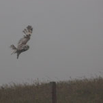
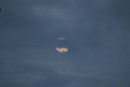
It is nearing dusk by the time I eat and I appreciate the protection. Though the wind blows, the sky remains relatively clear with the sun setting beyond the coast line. Tonight is the full moon and already it rises above the mountain to the east and south. From my temporary hide, the glass window of the hut allows me to peer out onto the loch's shoreline and there, perched on a fence post, sits a short eared owl. I duck out of sight and ready my camera in silence not wanting to alert it. I fit my zoom lens and set appropriate settings in haste, hopeful it is still there. It is. I reel off a few shots from my observation post and immediately alert him. It turns toward me and begins its launch as I continue to track him through the viewfinder and take more shots, attempting to frame him despite my movements and aware it would take time for him to gather momentum, aware its wing length compared to body size was immense, and aware it was looking straight at me. For a moment I was staring off a short eared owl. It circled round to a fence post on the other side of the loch and looked back at me as I went outside to take a few more shots and when it took off again it flew away and circled the next loch and over the ridge - it would not be hunting here again tonight. Night was drawing in and I sat for a while enjoying the moonlit scene, content I would be safe in my new found home (at least for one night). Tonight, above my refuge, the sky never blackened, these short summer nights and the full moon gave it a purple haze.
Next morning it is glorious. Favourable cirrus clouds adorn the turquoise sky. The sun shines and I take my time to eat my breakfast bars and make a pot of tea, absorbing and appreciating my surroundings at an easy leisure. It is early and I knew today would be warm, and long, and hard going, and by the look of the maps mostly on the road. Benbecula, the dark island of Gaelic poetry, is a relatively small low level island, mostly open moorland on the eastside and the windswept Machair and farmland to the west. A central road travels up its spine and the single lane coastal road round to the west is the route of the Hebridean Way. I reach the road quite quickly, my pace is good and I am well accustomed to my pack. Plus I was drinking and consuming the water I was carrying, making it lighter. I thought it necessary on this journey to carry 5 litres, enough for three days, for I knew fresh water would not easy to obtain, bar from a tap. By late morning I am approaching the causeway, where I find a supermarket, and a picnic bench, and I purchase and enjoy a local baked bridie, Stornaway duck pate on my oatcakes and a chilled IrnBru. Perfect Scottish fayre. I casually cross the causeway taking many photos along the way until I reach the other side and, in the 20 degree heat of the mid-day begin the route around the island, traipsing the tarmac,the combined weight of myself and my pack hard on the soles, that I knew was before me on this day's journey, aware in only a few hours I would be on the coastline and in the Machair once again, where here the western beaches are superb and I was determined I would paddle.
Eventually the road met the sand and at the first opportunity I welcomed the chance to relinquish the backpack and stretch out in the dunes above the beach. On this hot day people were out, appreciating the locality with the birds and bees of the Machair. Ragwort grew wild, as did the purple flowered Scottish thistle. Bees hovered from flower to weed. Flies gathered in the sunshine on the kelp washed u[p to shore at the end, where I sat, where the rocks meet the sand. However this first stretch of beach was not my destination. It was the next one a mile or so further north that I thought might give me an afternoon's rest and maybe a camp site, so I do not stop. It does not take me long, determined as I was, to reach and enter into a beautiful bay sheltered below the next set of dunes ahead. For the next few hours, having stashed my backpack in the high dunes and taken off my heavy hot boots and sweaty damp socks and transferred to open sandals, I was paddling in the cool sea as the waves gently lapped against the shore.
I explored the grassy banks either end of the bay for potential camping spots but was reluctant to hang out for the rest of the day. There was a hostel across the road from the beach but again I felt I could achieve nothing by stopping so early in the day. I was already slightly sunburnt on my calves despite my application of sun cream and I'm not a fan of sunbathing, my ginger based complexion and freckles are not suited to southern heat. By all accounts on this day Britain suffered a heatwave country wide. I also knew with every heat wave would come the inevitable electric storm and one was warned. I felt the best choice was not to sit (or lay) exposed on a beach if one should occur so instead chose to continue. The next causeway could be reached before dusk and Benbecula would have been walked in a day. Plus at the northern point, close to the causeway, was a marked but broken stone circle and not far from it a solitary standing stone, perhaps worth seeing before the day was out. But that would take a while still, so with that continual determination I hoisted the backpack into position and continued my pounding of the pavement north. Where the road turns eastward and inland I come to the town of Balivanich. It's like a big housing estate by comparison to what I had seen before on the island where there is an airport, a hospital, a supermarket, petrol, a bank and post office, and a restaurant, even a hairdressers and estate agent. I head for the petrol station because all I need is water and I thought they would be most likely to have a tap, but I was wrong, though the friendly hairdresser next door gladly filled up one of my two litre containers. I had needed to drink a lot through the day. With enough water to cook with later that night I continued, passing through like the wanderer. By now it was late tea-time and the sky was beginning to cloud over and that storm was forming. Clouds were gathering. Glad for the respite from the sun I rested up by the open road and spread out the map. I would make my destination by dusk, though where I would camp I had no idea. The next island was North Uist and again I am not sure I wanted to continue hiking roadways around the largest of the islands I was to visit on this journey. Perhaps I should think differently and take advantage of the local bus system and explore some vital points and the northern island of this trip, Berneray. I rang ahead to a few of the forthcoming hotels and found a room at the Lochmaddy Hotel available and reserved a few nights ahead. Lochmaddy, again off to the east, could be reached by the bus at the causeway and I knew there was an early bus at 9am-ish, it would be the same bus I used to Lochboisdale, and they could be flagged down if necessary, though I presumed at every vital junction is a bus shelter and probably a posted timetable if needed. I was sure tonight would be stormy and I would not be comfortable and what would come after I could not be sure, so better to be safe than uncomfortable, and from Lochmaddy I could plan the following days and catch up with the weather forecast – 4G does not exist as a roaming signal. 1G if lucky. With a plan that involved comfort at the end I ventured on. Worst case scenario I could walk through the night, for the nights are short, and one thing the nights are warm, throughout my whole trip I was never cold, often wet and windswept, but never cold. At this point I was sweaty and with that relentless determination I plodded on toward my destination and at the inland junction north, close to the causeway, a road ventured eastward, not far to open moorland where a single standing stone stood weathered for thousand of years.
Here I dropped my pack, hidden, and trekked in to the wild landscape, familiarising and calculating my distances with the position of small lochs and height patterns, with no pathway to follow, seeking out any potential camp site amongst the mounds of heathen peat-land, searching for dry land that would not suffer from a temperate downpour that would come with the electric storm, some lower ground to deflect against lightning, but none was obvious. Perhaps a ½ mile into the terrain no standing stone was apparent and nothing lay before me that I could scope. Before lay peat bog and water, but to my left on the horizon perhaps another half hour or so away from, picked out by my scope, a stone stood proud, weathered, but forceful against the elements and silhouetted against the open sky horizon. It stood perhaps four or five feet high. I photographed it from that distance content to have seen it and aware the night was drawing in, I still hadn't eaten and nor had I a plan. Retracing my steps to the road and my pack I meet and chat with a neighbour and we discuss winds, standing stones, causeways and employment on the island, and the EU. He also tells me of an abandoned warehouse down by the causeway where I would get shelter from the wind to cook by, so I thank him and go off to explore possibilities. Sure enough the warehouse is abandoned and most people who know me know I have an interest in derelict spaces, so I explore with delight, and sure enough there is shelter from the wind where I cook and eat and think where I could camp. By now the sun is setting and I wander around the base of the causeway, taking pictures, and considering possibilities. I wander back to the warehouse and try a door, and it opens into a small entrance corridor about 15 feet long. The door at the end is locked, there is no access into the building. I try a few other doors and attempt to lift the shutters. Doors round the back and side were boarded and chained. But this was enough. There was room to stretch out. I had my mattress and sleeping bag, so I settled in for the night. And I was glad that I did. I thank the person that knew that one day it would be needed. That night it was not silent, as by midnight the thunder and lightning began, the heavens opened and a deluge of rain poured. I watched it from my shelter. After the idyllic sunset I had photographed, a great reward and well worthy after the days efforts, for the moon still appeared full and had shone down on the bay as the winds picked up and blew in the storm. The thunder clashed as the lightning flashed across the landscape, it was right in top of me, and I watched it from behind the glass window set in the door, thankful. And I slept comfortably, for it had indeed been a long day and my feet ached, waking a few times as the thunder roared some more as the sky would light up and the battering of rain would lull me back to sleep, where I dreamt. Dreams had been good on the islands.
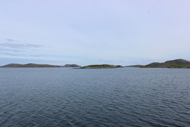
I was awake early, with the dawn, and packed quickly; I had hardly unpacked, and crept out from my haven, under clearer skies, though the wind still blustered, pushing away the thunderstorm. Across the road, from the warehouse, is the site of the stone circle, now in ruins and I visit it briefly, mission complete before taking to the causeway and crossing as the first traffic hits the roads. This is a long curving causeway onto the Isle of North Uist where I take ample opportunity to photograph the bird life amongst the rocks and out to sea, watching out for otters exploring the shores and perhaps seals bobbing on the water. I see neither. By early breakfast I am sat at the junction, where there is a bus shelter, with time to kill until the early bus to Lochmaddy. I enjoy my bus ride through the landscape, following the road that circles the island anti-clockwise where it eventually turns right taking a south-easterly road to the harbour town where it links to the ferry to Uig on Skye and my eventual route off the southern Outer Hebrides. I was happy to pay my £2.80 and witness the rolling moorland and landscape of the eastern side of North Uist slip by me from the comforts of the bus, rather than experience trekking the confines of the hardened surface of the road for several days. By mid morning I had arrived at the hotel and dumped my bag and was strolling the roads of the village, exploring the vicinity, whist waiting for my room to be ready having breakfasted on fresh baked fruit pastries and iced shortbread with a pot of coffee to accompany. Though I had survived the storm I was tired and would be glad of a shower. I had glanced at the specials menu in the bar from the night before and a few local treats perked my interest and I was looking forward to the cuisine during my stay. Apparently the chef is a pastry chef, hence the mid morning delicacies. Nice! From here, I have decided, I will explore the limits of the island by local bus, visiting the tourist information centre in the harbour I get copies of the bus routes. Lochmaddy also has a shop, and a bank, and a gift shop, and a glorious visitor centre telling and showing the history of the islands, exhibiting local art, with a cafe and shop. There is another hotel and restaurant, several B&Bs, a hostel and activity centre, a local hall and the police station. There is a newly built harbour offering short term refuge and rest for ocean vessels and occupants journeying the continual excessive open sea. That night I dined on Chicken Balmoral – chicken breast stuffed with Stornaway haggis and wrapped in Pancetta ham served with home-made potato croquettes and a mixed vegetable palette of asparagus, mange tout, cauliflower and carrots. And at this point I will compliment the chef at the Lochmaddy Hotel. During my stay I sampled fresh lemon sole, North Uist scallops, lightly battered squid rings that melted in the mouth, breast of duck, North Uist beef and lamb steak, each cooked with care and attention, where presentation mattered. The food was excellent and popular, the friendly staff worked well and hard due to the demand. As a resident it proved necessary to book a table.
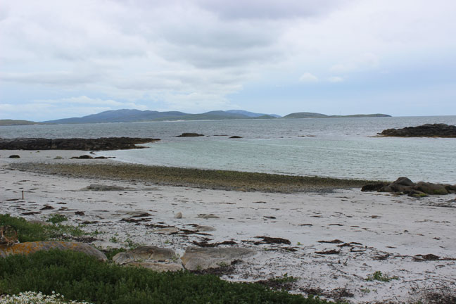
Day one exploring North Uist by bus saw me catch the morning transfer to the northern Isle of Berneray where, once over the causeway I am dropped at the ferry harbour where I could have continued my journey north to South Harris. Instead my intention is hike a circular route around the island and I head along the road following it to the south westerly point of the western coastline; 3 miles of white sands, perhaps the finest of all on my journey and a particular bucket-list destination and ambition of mine for twenty years. On route I witness another short eared owl hunting the moorland where at its peak a single standing stone still perseveres, pausing to photograph for while before striking out toward the coast pleased to be walking without my backpack, pleased that the day is fine, so far. On this day I am alone on the beach and I wander its length in solitude for the duration as the sea gentle laps wave after wave onto the flat, smooth beach, taking photograph after photograph, eager to absorb and capture the calm and peace of the coastal environment. Today, here, I am the monk by the sea. At the end of the beach I climb up to the high trig-point on the hill with a 360 degree panoramic view of the island, though at this point in time the wind blew in a brisk shower that misted out some of my view. I ascend to the grassy banks of the Machair at the northern point where marram grass grows tall amongst the sand dunes and many camper vans sit parked up and tents are pitched, an accessible free camping spot on this picturesque peninsula, with sea view. Here there is an hostel too, a pretty white painted thatched croft, again with sea views. At the height of summer this plateau is rich with Scottish harebells, no doubt admiring the sea view, but on this day the daisies and buttercups cover the meadow as I walk through, heading back to the road and circling round to the eastern side and the rocky bays where the community of the island has built up. In the bay I see resident grey seals and common seals, basking on the rocks in the sunshine, or diving into the depths, then resurfacing to bob for a while, before diving again, on the hunt. I stroll through the village along the road, stopping for a short while to chat to an artist selling her wares and crafts from a caravan gallery by the road, before heading back to my start point to catch the late afternoon bus back in time for tea.
A Monk by the Sea (after Casper David Friedrich)
Day two by bus sees me follow the circular route clockwise to the far western side, to the RSPB nature reserve at Balranald, where I disembark and explore the protected coastal dunes and Machair. The fields are dotted with yellows and whites, and red poppies, and the unique early marsh orchid. Fulmars and terns and plover feed on the kelp and sea rocket in the small bay and I follow the path around the bay to the dunes, then back, enjoying once again the extent of nature before me, before continuing the road north and inland where I pass by houses and homes, north to Hosta where I know the North Uist Highland games is occurring, and I pay my entry fee and visit, to watch tossing of the caber, the shot putt, many races, highland dancing, bagpipe playing, and the usual stalls and excitement you might expect from a local community. I don't stay till the end, missing the tug of war which I am sure would have been fun, but the crowds are already thinning, I was a long way from LochMaddy and it was my hope to hitch back to the eastern side, so I depart and do not walk far before I am offered a lift, by a man on his way home from the games, to Lochmaddy, where he resides. Everywhere, by comparison, is so quick to reach by car. We pass by the huge forest plantation at the north of the island, and to my left and before me are the expanse of white sands that have established the northern coast line and the bay across to Berneray, and as we turn to the south east, where the road is high, I am treated to a spectacular view before me as the road begins an ascent to the opposite coastline, back to Lochmaddy, once again in time for tea.
About 8 miles inland from Lochmaddy is an neolithic stone circle, Pobull Fhinn – Fionn's People. It stands, not far from the road, at the bottom of a slope by a loch, and this is my destination for the day's walk on day three. Whereas yesterday had remained fine all day, today was cloudy and misty and there was rain in the wind, and the wind was stronger. I hike the distance out of Lochmaddy joining with the old road out to the harbour and so avoiding the minimal traffic on the road, though it is never far away. But I enjoy the scenery as I pass by the small lochs and moorland that stretches for miles to distant peaks in the mist. And I enjoy the rain, and the walk and spending the morning reaching the hill by the road where, on the slope, there is a small educational woodland, proof of what you could do with the right resources, and I stroll between the trees, out of the wind, before embarking up onto the open moorland beyond, to reach the high trig-point, taking an approach that traces the original, now wild, Hebridean Way Trail, before descending the opposing slope to find Pobull Fhìnn by the loch. Halfway down I sit to contemplate my directions, familiarising myself with the landmarks and the map, and so calculate my descent. Whilst I rest a hen harrier launches itself against the wind and sears across the landscape, on the hunt, whilst I attempt to snap photographs of it through my lens. Pobull Fhìnn is comprised of 31 stones, some lay on their side, some may not be accounted for and are buried in the peat. Most of them still stand indicating the size of the circle and its key points and largest stones. I spend a good hour taking photographs and walking around its periphery, through the middle and back out. In the valley is a small hotel and restaurant, with a beautiful garden and protected by a small copse. It would be very peaceful staying here. By now it is late afternoon and I stop for a pint in the bar. Departing by the track to the road, an easier way than the way I arrived, I am on the road and hitching back, thankfully picked up, again by a local off to the shop for a paper, and I was back in time for tea.
An ancient trail; the Hebridean Way was a route taken 4000 years ago to Pobull Fhìnn.
My final day on the islands, a Sunday, for on Monday I would cross to Uig in North Skye and it would take me a day to get to the south of Skye where, by ferry from Armadale, I could link to the train on the mainland and home, two weeks in the Outer Hebrides. I always like my Sundays to be a day of rest if they can, and I spent the morning catching up on notes in my journal so I could remember the highlights and tell this tale, which was okay whilst it was raining, but in the afternoon the sun came out and I took a stroll around the small bays surrounding the village and took a farmer's track across the moor – my last chance to enjoy the wild landscape and such special eco-system, taking a loop back to the village via the road, where the neighbouring lochs were filled with white water lillies, meadow brown and small white butterflies skim the wild flowers and purple heather and tall green ferns, geese sit in the bays, as the rain began again, and it was time to make haste, in time for tea.
I have waited to walk these islands for twenty years, but with only two weeks here I know I will need to come again, for as ever there is much I did not see. I did not see otters, or eagles, but I did see the great yellow bumble bee. What I did see was amazing, and special. If I was to be critical of the Hebridean way it needs to find a way to get walkers off the road. As the west coast is relatively flat, it's great for cyclists, of which I saw a few (though I am sure the wind can be a problem), and most excellent for camper vans, of which there are many and likely to get plentiful. There needs to be more stiles allowing access across the barbed wire marking the strips of grazing land that so often forces a walker to the highway and missing the key excitement of the journey along the Machair. There needs to be access to water along the way if it is to be promoted. Equally I would say to anyone travelling the route, camping out and enjoying the wilderness, as many do by foot, bike or van, take opportunity to dine and shop locally and try the local cuisine; fish, seafood, beef and lamb - there is a good choice of restaurants along the way and all make the effort to present local fayre and produce. The islands promote a food trail, and an art trail and are pleasant and welcoming. I wish I could have sampled more of everything. I will return.
© darkroomarts 2016 The Lochboisdale Hotel http://www.lochboisdale.com/ The Lochmaddy Hotel http://www.lochmaddyhotel.co.uk/ Calmac Ferries http://www.calmac.co.uk bibliography Peter May, The Coffin Road, January 2016 Anthony Giddens, The Third Way, 1998 references 1 A programme supported by the Scottish Natural Heritage, ERDF, Local Council and Outer Hebrides Tourism 3 Opened in 1991, supported by EU FUNDING. |
|---|